With World Bank
Measuring Rural Accessibility to Crucial Services
A routing platform to identify and address underserved populations

.jpg)
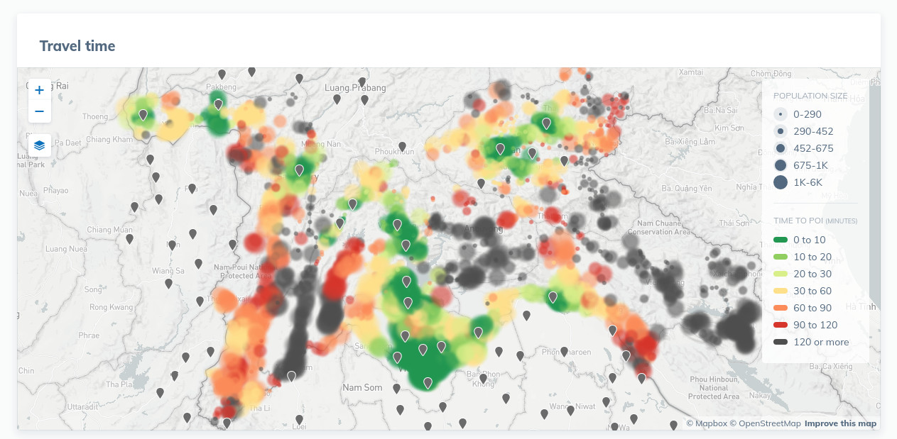
Rural Accessibility Map (RAM) uses state-of-the-art routing algorithms to model the impact of road networks on access to crucial services. Road planners use RAM to determine what road investments will have the greatest impact on access to schools, markets, and hospitals. Disaster planners can use RAM to model the impacts of floods or earthquakes on mobility. Together with Taurus, our collaborative road management application, RAM gives planning offices at all levels the tools to make wise investment decisions.
We’re developing RAM with the World Bank, who believe that accessibility goes hand-in-hand with alleviating poverty. RAM works anywhere in the world. It’s algorithm allows input tuning for road speed and traffic, producing accurate models for both rural or urban areas, in normal load or under the duress of a natural disaster.
RAM is open source and currently in beta, with development ongoing. You can grab the source code and run it here.
Narrow Focus, Flexible Uses
RAM is a single-purpose tool with many uses. RAM draws its data from OpenStreetMap (OSM), a massive database of roads and service locations. However you can easily adjust it to use your own points of interest and road network, in many geographic file formats. You can also tune RAM to take an arbitrary average movement speed into account, to model for situations from congested urban areas to sprawling rural land. This allows you to explore many scenarios and situations. You can look at the the impact of creating a new crosstown connector highway, or look at the best place to locate your new shoe shop.
On the Cloud or in the Field
Under the hood, RAM uses OSRM, a fast, open source routing engine, to perform the massive calculations needed for assessing travel-time from populated areas. To manage all these heavy computations we built http://ruralaccess.info/ on the Amazon Web Services (AWS) cloud. There RAM will intelligently scale up or down to meet demand. This ensures that even the most demanding analysis finishes quickly.
RAM can trade some of this processing speed to work in a local laptop. This allows RAM to function in areas without access to high speed internet. We are currently working with partners who are interested in using RAM in post-disaster environments, to reassess accessibility where roads are inaccessible and to plan the distribution of relief resources.
Improving Accessibility with Open Tools
RAM is open source and uses open data by default. The entire application lives in a Docker container, meaning it can be deployed on almost any machine. Planning agencies and governments can use RAM without paying expensive licensing or maintenance fees. This aspect is key to ensuring that local authorities always have access to the tools they need to reach underserved communities.
We’re continuing to develop RAM with the World Bank, and looking for places to deploy it. The code is available on Github, and we’re watching the issues queue for any bug reports or feature requests. Take a look, we’d love to hear your feedback.
For more on our efforts in this space, read about Taurus, a collaborative road management platform for editing and exporting accurate geographic data.